Fort Worth

FortWorthWeekly.news · Western roots. Modern Fort Worth news.

Back to Weather

5-day forecast / Fort Worth, TX

SaturdaySunny98° / 78° 1%
SundaySunny then Chance Showers And Thunderstorms97° / 76° 45%
MondayChance Showers And Thunderstorms94° / 74° 38%
TuesdayChance Rain Showers then Slight Chance Showers And Thunderstorms93° / 74° 26%
WednesdayMostly Sunny then Slight Chance Showers And Thunderstorms93° / 75° 18%

Dangerous Heat Index Hits 104 in Fort Worth Today - Jul 11, 4 PM

Fort Worth weather, updated every four hours — local forecasts you can trust.

Fort Worth faces dangerous heat with a heat index of 104F today. Humidity is high at 42%. Scattered storms possible tomorrow.

Tessa Whitlock

July 11, 20262 min read

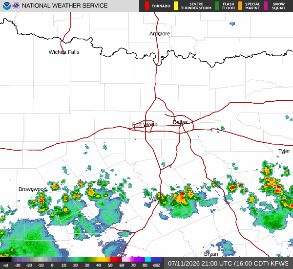
National Weather Service radar for North Texas (KFWS)

*As of Jul 11, 4 PM local time.*

Dangerous Heat Arrives in Fort Worth

Fort Worth is currently under the influence of dangerous heat conditions this Saturday afternoon. The air temperature stands at 97F, but the heat index makes it feel like 104F. This significant discrepancy is driven by high humidity levels; the relative humidity is at 42%, with a dew point of 70F. Winds are currently blowing from the south at 11 mph, with gusts reaching 10 mph, while the sky remains mostly clear.

Forecast for Today and Tomorrow

Today, the sun will dominate the sky, bringing a high near 98F. The heat index will remain elevated, peaking at 104F. Overnight, conditions will clear up, allowing temperatures to drop to a low near 78F. However, warmth will linger, with temperatures rising to around 80F during the night. The heat index will stay high at 103F, with south winds continuing at 5 to 10 mph. The chance of precipitation is minimal at just 1%.

Tomorrow, the pattern shifts slightly. The day will begin sunny with a high near 97F. However, a chance of showers and thunderstorms develops after 1pm. The heat index will reach 104F again, with temperatures falling to around 95F in the afternoon. South winds will lighten to around 5 mph. The chance of precipitation is listed at 45% in the general forecast, though the detailed outlook suggests a 50% chance with new rainfall amounts less than a tenth of an inch possible. Temperatures will drop to a low near 76F, rising to around 78F overnight. Partly cloudy skies will accompany a chance of showers and thunderstorms before 7pm, with likely storms between 7pm and 10pm. The heat index will be 101F, with east southeast winds at 0 to 5 mph.
Safety Reminders

Given the dangerous heat index values, it is crucial to stay hydrated and limit midday exertion. Check on neighbors, especially the elderly and those without air conditioning. While storms are possible tomorrow, the primary concern today is the extreme heat. Stay cool and safe.

National Weather Service radar for North Texas (KFWS)

Sources

https://radar.weather.gov

https://api.weather.gov

https://open-meteo.com

Share

Tessa Whitlock

Tessa Whitlock covers weather, storms, and seasonal life around Fort Worth.

Related Stories

More in Sport